Arctic sea ice disappearing fast
Above image, from the National Institute of Polar Research in Japan, shows Arctic sea ice extent at a record low for the time of year, on July 4, 2021, at 8.4 million km².
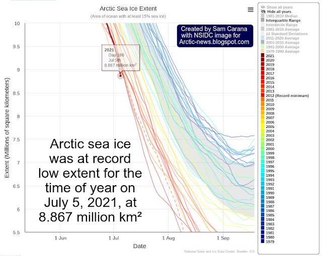
Subsequently, the NSIDC also indicated that Arctic sea ice was at record low extent for the time of year, on July 5, 2021, at 8.867 million km² (image above).
Arctic sea ice is getting very thin rapidly, threatening the latent heat tipping point to get crossed soon.
The U.S. Navy animation on the right shows Arctic sea ice thickness (in m) for the 30 days up to July 7, 2021, with eight days of forecasts included.
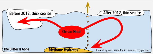
As sea ice gets thinner, ever less ocean heat gets consumed in the process of melting the subsurface ice, to the point where there is only a thin layer of ice left at the surface. While this thin layer of ice may remain at the surface for as long as air temperatures are still low enough, and this ice will still consume some heat at the bottom, at the same time it acts as a seal, preventing heat from the Arctic Ocean to enter the atmosphere.
And while the situation in 2021 is dire, the outlook for the years beyond 2021 is that things look set to get progressively worse.
This situation in 2021 is the more remarkable given that we’re in a La Niña period, as illustrated by the NOAA image on the right showing a forecast issued July 5, 2021, that indicates that La Niña is expected to reach a new low by the end of 2021.
Sunspots are on the rise. We were at a low point in the sunspot cycle late 2019/early 2020. As the image on the right shows, the number of sunspots is rising and can be expected to rise further as we head toward 2026, and temperatures can be expected to rise accordingly.
According to James Hansen et al., the variation of solar irradiance from solar minimum to solar maximum is of the order of 0.25 W/m⁻².
Temperatures are currently also suppressed by sulfate cooling, and their impact is falling away as we progress with the necessary transition away from fossil fuel and biofuel, toward the use of more wind turbines and solar panels instead. Aerosols typically fall out of the atmosphere within a few weeks, so as the transition progresses, this will cause temperatures to rise over the next few years.
So, the outlook is grim. The right thing to do now is to help avoid the worst things from happening, through immediate, comprehensive and effective action as described in the Climate Plan.
Links
• National Institute of Polar Research (NIPR) in Japan
https://ads.nipr.ac.jp/vishop
• The National Snow and Ice Data Center (NSIDC) at the University of Colorado Boulder
https://nsidc.org/arcticseaicenews/charctic-interactive-sea-ice-graph
• NOAA ENSO Evolution
https://www.cpc.ncep.noaa.gov/products/analysis_monitoring/lanina/enso_evolution-status-fcsts-web.pdf
• Naval Research Laboratory of the U.S. Navy
https://www7320.nrlssc.navy.mil/GLBhycomcice1-12/arctic.html
• Latent heat
https://arctic-news.blogspot.com/p/latent-heat.html
• University of Bremen – sea ice
https://seaice.uni-bremen.de
• Aerosols
https://arctic-news.blogspot.com/p/aerosols.html
• Climate Plan
https://arctic-news.blogspot.com/p/climateplan.html


